6 minutes
ECOM7123 Open Data & Spatial Data Infrastructure (SDI)
.png)
Data in Smart Cities
Overview
- real time data
- collected from
- devices
- sensor network
- IoT
- sources
- parking spaces
- city trash bins
- vehicles
- energy turbines, etc.
- collected from
- data: existing in different forms
- data in cloud
- pay for actual usage
- centralized & remote management
- accessible in different locations
- big data
- large and complex data sets
- difficult to be handled by traditional technologies like relational database
- requires new technologies and processing applications like Hadoop to deal with
- spatial data
- 80% of data generated in our daily lives are spatial data
- identifies the geographic location of features and boundaries on earth
- data in cloud
- value of data in developing smart city
- to understand where, when, how and why
- to support policy-making
- to optimize operations
- to enable smart apps and services
Future
- stimulating innovation
- revolutionizing business models
- creating new jobs
- improve quality of life
Open Data
Overview
- definition
- refers to information that can be freely used, modified, & shared by anyone for any purpose
- it must be available under an open licence & provided in a convenient and modifiable form that is machine readable
- is not just about sharing data
- it is also about using it in innovative ways, such as creating apps and solutions with it and helping stakeholders make data-driven decisions
- setting up an open data site allows citizens, government employees, developers, startups, and more, to launch new solutions and applications almost immediately
- 8 principles of open data
- complete
- primary
- timely
- accessible
- machine processable
- non-discriminatory
- non-proprietary
- license-free
Advantages and disadvantages
- advantages
- individual
- make more informed decisions & new services
- business
- cost-effective resource to combine with proprietary databases
- government
- increase transparency & collaboration
- direct improved city planning & job creation
- driving economy
- global
- location-based open data could suggest sustainable solutions to address the problems
- individual
- disadvantages
- privacy concerns
- lose control over confidential information
- expense of creating and curating an open data portal
- data must be machine-readable
- constant updating and promotion
- effort must be spent engaging the community
Aggregate information
- definition
- collective data that relates to a group or category of services or customers, from which individual customer identities & characteristics have been removed
- function
- to utilize these data can promote efficiency and create opportunities to the community
- key points
- using crowdsourcing
- a serious limitation - the data mainly depends on the number of service subscribers, and cannot be comprehensive
- government open data + aggregate information -> form complete pictures of relevant fields
The roadmap for open data infrastructure - 10 key steps
- understand & advocate
- resource & govern
- align & integrate
- create & commit
- secure & protect
- build capcity
- prioritise & crowdsource
- connect & communicate
- maintain & sustain
- listen, adjust & share
Spatial Data Infrastructure (SDI)
Overview
- data is “new oil”
- spatial data sharing as a smart city infrastructure
- definition
- the term Spatial Data Infrastructure was coined in 1993 by the U.S. National Research Council to denote a framework of technologies, policies and institutional arrangements that together facilitate the creation, exchange, and use of geospatial data and related information resources across an information-sharing community
- such a framework can be implemented narrowly to enable the sharing of geospatial information within an organization or more broadly for use at a national, regional, or global level
- in all cases, an SDI will provide an institutionally sanctioned, automated means for posting, discovering, evaluating, and exchanging geospatial information by participating information producers and users
- SDI extends a GIS by ensuring geospatial data and standards are used to create authoritative datasets and polices that support it
- IGIF (The Integrated Geospatial Information Framework)
- note: geospatial information is a nation’s “digital currency” for evidence-based decision-making
- note: geospatial information is a nation’s “digital currency” for evidence-based decision-making
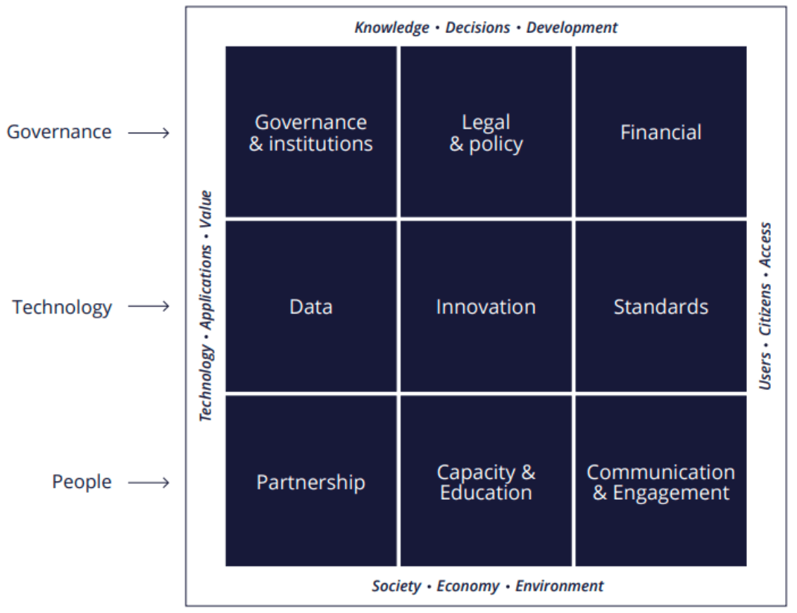
- what is behind to build a SDI
- policy & institutional framework
- data & technical standard
- technologies & applications
- people & sharing
- summary
- SDI provide government departments as well as public and private organisations with an information infrastructure to share spatial data, supporting smart city applications
CSDI (Common Spatial Data Infrastructure)
- framework
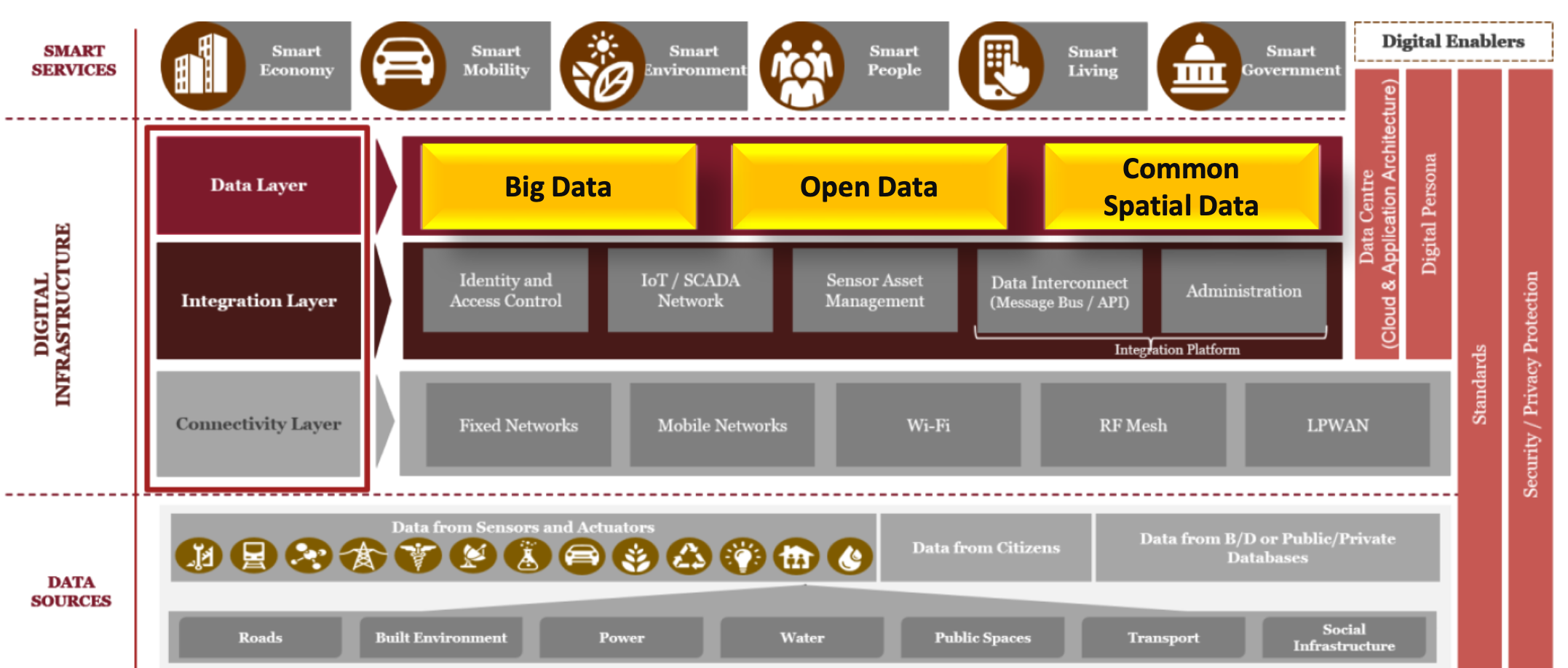
- importance
- better city planning & management
- unlock the wealth of existing knowledge & boost the economy
- make right and agile decisions
- potential applications
- COP (Common Operation Picture) - online operations dashboard
- provides a central location to access a suite of maps and applications for the various groups within the Emergency Operations Center (EOC)
- the applications support focused workflows and allow each group to contribute to a common operational dataset through a shared services catalog
- risk assessment
- pattern and hotspots analysis
- route planning & navigation
- spatial market research
- COP (Common Operation Picture) - online operations dashboard
Spatial data management
- backbone technology
- GIS (provides the location platform)
- integrating people, processes, things, and data about them
- system of engagement
- system of record
- system of insight
- using the power of where to integrate everything
- GIS (provides the location platform)
SDI around the world - examples
- GeoPlatform
- INSPIRE Geoportal (EU)
- OneMap (Singapore)
- The SDG (Sustainable Development Goals) Hub (UN)
- Los Angeles GeoHub
- success factors
- explorable data
- includes map and operational data
- opens data internally and externally
- launches apps for immediate use
- provides context of issues through story maps
- offers training and developer resources
- leverages a larger ecosystem
- success factors
- map-centric city dashboard
- contents
- provide at-a-glance views of KPI
- interactive (trigger response in other elements)
- support real-time data feeds
- data display includes a map or spatial context
- share with others
- key usage pattern
- monitor and manage operations/assets
- IoT
- COP
- event management
- situational awareness
- emergency management
- executive summaries
- visualize & compare
- reporting dashboard
- monitor and manage operations/assets
- CSDI readiness to map-sensitive dashboard
- a map is worth a thousand words (such as the period of Covid-19)
- contents
Summary
Begin with smart response
- a smart future begins with a smart response to changes and challenges
- a smart response begins with the adoption of essential technologies which generate large volume of real-time spatial data in open format
To enable public engagement
- for citizens
- to voluntarily collect information about surroundings and share with the community
- for government
- use SDI to aggregate the data to identify hot spots of services
- to inform citizens and seek their approval when drafting development plans for the future
To build a hub of innovation
- SDI and open data strategy creates the infrastructure for information sharing, solution creation, and innovation
- data and initiatives in SDI can be actionable and reusable by different communities in the city
- a hub of innovation can be built together by government departments, NGOs, startups, academia, businesses, and citizens
An open and smarter future
- open data and SDI bring more collaboration and transparency by enabling citizens, businesses, NGOs, academia and government departments working together
- a Smart City enabled by open data and SDI is a place where people feel safe, healthy, happy and motivated to improve
SDI is an enabling technology
- today’s government & communities need collaboration
- people
- process
- data
- technology
- example
- 3D Singapore Sandbox @ GeoWorks
Additional Reading
ecom7123 building smart cities: an information system approach smart city open data spatial data infrastructure sdi
1100 Words
2021-01-08 09:20